
Mapa topográfico Castlemore
Mapa interativo
Clique no mapa para exibir a altitude.
Sobre este mapa
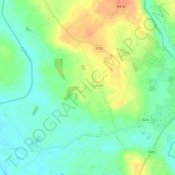
Nome: Mapa topográfico Castlemore, altitude, relevo.
Altitude média: 78 m
Altitude mínima: 61 m
Altitude máxima: 101 m
Outros mapas topográficos
Clique em um mapa para visualizar sua topografia, sua altitude e seu relevo.
Mountain River
Mountain River, The Municipal District of Muinebeag, County Carlow, Leinster, Ireland
Altitude média: 136 m
Fennagh
Fennagh, Ballyknockan, Fennagh ED, The Municipal District of Muinebeag, County Carlow, Leinster, Ireland
Altitude média: 96 m
Derreen
Derreen, Butlersgrange, Tullow Rural ED, The Municipal District of Tullow, County Carlow, Leinster, Ireland
Altitude média: 95 m
Bagenalstown
Ireland > County Carlow > Bagenalstown
Bagenalstown, The Municipal District of Muinebeag, County Carlow, Leinster, R21 DR77, Ireland
Altitude média: 75 m
Palatine
Palatine, Killyshane, Burtonhall ED, The Municipal District of Carlow, County Carlow, Leinster, R93 Y381, Ireland
Altitude média: 76 m
Borris
Borris, The Municipal District of Muinebeag, County Carlow, Leinster, R95 C92R, Ireland
Altitude média: 60 m
Vermount
Vermount, Clonmore ED, The Municipal District of Tullow, County Carlow, Leinster, Ireland
Altitude média: 153 m