
Faça uma doação
Mapa topográfico Chiro
Clique no mapa para exibir a altitude.
Faça uma doação
Chiro
Chiro (also called Asebe Teferi or Asba Littoria; Afaan Oromo: Ciroo) is a town and Aanaa in eastern Ethiopia. Located in the West Hararghe Zone in Oromia Regional State, Ethiopia Ahmar Mountains, it has a latitude and longitude of 9°05′N 40°52′E / 9.083°N 40.867°E / 9.083; 40.867 and an altitude of 1826 meters above sea level. It is the administrative center of the West Hararghe Zone in Oromia Regional State.
Faça uma doação
Sobre este mapa
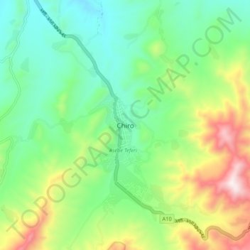
Nome: Mapa topográfico Chiro, altitude, relevo.
Local: Chiro, West Harerghe, Oromia Region, 0165, Ethiopia (9.04706 40.82752 9.12706 40.90752)
Altitude média: 1.870 m
Altitude mínima: 1.603 m
Altitude máxima: 2.421 m
Faça uma doação
Outros mapas topográficos
Clique em um mapa para visualizar sua topografia, sua altitude e seu relevo.
Asela
Asella (Oromo: Asallaa, Amharic: አሰላ) is a town in central Ethiopia. Located in the Arsi Zone of the Oromia Region 126 km (78 mi) south from Addis Ababa, this town has a latitude and longitude of 7°57′N 39°7′E / 7.950°N 39.117°E / 7.950; 39.117, with an elevation of 2,430 meters. Asella…
Altitude média: 2.429 m
Faça uma doação
Lake Abaya
The only outflow of the lake is through the lower reaches of Kulfo River directly below an alluvial fan at an elevation of 1,190 m (at 6°00′39″N 37°35′07″E / 6.0109°N 37.5854°E / 6.0109; 37.5854). The riverbed acts as an spillway in the case of high lake levels and discharges the excess…
Altitude média: 1.471 m
Faça uma doação
Moyale
Moyale has a hot semi-arid climate (Köppen BSh) moderated somewhat by altitude. Typically for East Africa, there are two rainy seasons: the “long rains” from March to May and the weaker, less reliable “short rains” in October and November.
Altitude média: 1.095 m
Harena Forest
The Harenna Forest is a montane tropical evergreen forest in Ethiopia's Bale Mountains. The forest covers the southern slope of the mountains, extending from 1450 to 3200 meters elevation. The Bale Mountains are in Ethiopia's Oromia Region, and form the southwestern portion of the Ethiopian Highlands.
Altitude média: 2.028 m
Faça uma doação
Asela
Asella (Oromo: Asallaa, Amharic: አሰላ) is a town in central Ethiopia. Located in the Arsi Zone of the Oromia Region 156 km (97 mi) south from Addis Ababa, this town has a latitude and longitude of 7°57′N 39°7′E / 7.950°N 39.117°E / 7.950; 39.117, with an elevation of 2,430 meters. Asella…
Altitude média: 2.429 m
Asela
Asella (Oromo: Asallaa, Amharic: አሰላ) is a town in central Ethiopia. Located in the Arsi Zone of the Oromia Region 126 km (78 mi) south from Addis Ababa, this town has a latitude and longitude of 7°57′N 39°7′E / 7.950°N 39.117°E / 7.950; 39.117, with an elevation of 2,430 meters. Asella…
Altitude média: 2.429 m
Faça uma doação
Faça uma doação