
Obrigado por apoiar este site ❤️
Faça uma doação
Faça uma doação
Mapa topográfico Alibag
Clique no mapa para exibir a altitude.
Obrigado por apoiar este site ❤️
Faça uma doação
Faça uma doação
Alibag
Alibag is located about 120 km south of Mumbai, at 18°38′29″N 72°52′20″E / 18.64139°N 72.87222°E / 18.64139; 72.87222. The average elevation is 0 metres (0 feet).The District Government offices are located along the sea coast road. Alibag is the center place of Raigad District.
Obrigado por apoiar este site ❤️
Faça uma doação
Faça uma doação
Sobre este mapa
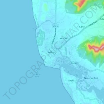
Nome: Mapa topográfico Alibag, altitude, relevo.
Altitude média: 12 m
Altitude mínima: -2 m
Altitude máxima: 255 m
Obrigado por apoiar este site ❤️
Faça uma doação
Faça uma doação