
Faça uma doação
Mapa topográfico Draper
Clique no mapa para exibir a altitude.
Faça uma doação
Draper
Draper's climate is roughly identical to other Salt Lake City suburbs. However, due to being further away from the Great Salt Lake, varied elevation, and from the downtown urban heat island effect, Draper experiences a slightly drier winter and more extremes in temperatures.
Faça uma doação
Sobre este mapa
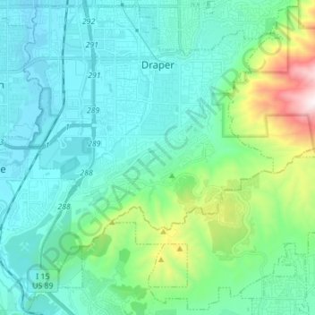
Nome: Mapa topográfico Draper, altitude, relevo.
Local: Draper, Salt Lake County, Utah, 84020, United States (40.45171 -111.92199 40.54435 -111.78321)
Altitude média: 1.570 m
Altitude mínima: 1.317 m
Altitude máxima: 2.715 m
Faça uma doação
Outros mapas topográficos
Clique em um mapa para visualizar sua topografia, sua altitude e seu relevo.
Jordan River OHV/ Modelport State Park
United States > Utah > Salt Lake County > Salt Lake City
Altitude média: 1.286 m
Faça uma doação
Faça uma doação
Salt Lake City
United States > Utah > Salt Lake County > Salt Lake City
Salt Lake City has an area of 110.4 square miles (286 km2) and an average elevation of 4,327 feet (1,319 m) above sea level. The lowest point within the boundaries of the city is 4,210 feet (1,280 m) near the Jordan River and the Great Salt Lake, and the highest is Grandview Peak, at 9,410 feet (2,868 m).
Altitude média: 1.625 m
Faça uma doação
Faça uma doação
Faça uma doação
Meridian Peak
United States > Utah > Salt Lake County > Salt Lake City
Meridian Peak can be found at the southern end of Elliot Ridge Trail. It can be reached by ascending several hiking trails into the Gore Range. Surprise Lake Trail goes south for 2.6 miles to Surprise Lake, then the Gore Range Trail continues west for 1.9 miles to a junction with the Upper Cataract Lake and…
Altitude média: 1.698 m
Faça uma doação
Brighton
United States > Utah > Salt Lake County
Brighton has a high-altitude cold continental climate (Köppen Dsb/Dsc), with dry summers and very snowy winters.
Altitude média: 2.852 m
Faça uma doação