
Mapa topográfico Roseburg
Mapa interativo
Clique no mapa para exibir a altitude.
Sobre este mapa
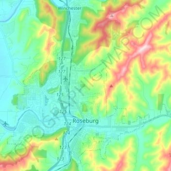
Nome: Mapa topográfico Roseburg, altitude, relevo.
Local: Roseburg, Douglas County, Oregon, United States (43.19052 -123.40198 43.28152 -123.27021)
Altitude média: 239 m
Altitude mínima: 116 m
Altitude máxima: 546 m
Roseburg's elevation is approximately 500 feet (150 m). Its highest point is Mount Nebo, a 1,200-foot (370 m) hill to the west of Interstate 5. Through the 1980s, it was known for its band of 10-20 feral angora goats. Residents said they could predict the weather by watching where the goats were on the mountain; if they were high, the weather would be good. If rain was pending, the goats moved to lower levels. Because the goats wandered across the freeway for grazing, they were a risk to traffic. In the 1980s, they were rounded up and placed for adoption.
Outros mapas topográficos
Clique em um mapa para visualizar sua topografia, sua altitude e seu relevo.
Canyonville
United States > Oregon > Douglas County
Canyonville, Douglas County, Oregon, 97417, United States
Altitude média: 272 m
Days Creek
United States > Oregon > Douglas County
Days Creek, Douglas County, Oregon, United States
Altitude média: 333 m
Melrose
United States > Oregon > Douglas County
Melrose, Douglas County, Oregon, United States
Altitude média: 173 m
Galesville Reservoir
United States > Oregon > Douglas County
Galesville Reservoir, Douglas County, Oregon, United States
Altitude média: 655 m
Lookingglass
United States > Oregon > Douglas County
Lookingglass, Douglas County, Oregon, United States
Altitude média: 211 m
Tenmile
United States > Oregon > Douglas County
Tenmile, Douglas County, Oregon, 97481, United States
Altitude média: 279 m
Fair Oaks
United States > Oregon > Douglas County
Fair Oaks, Douglas County, Oregon, United States
Altitude média: 222 m
Umpqua
United States > Oregon > Douglas County
Umpqua, Douglas County, Oregon, United States
Altitude média: 137 m
Drain
United States > Oregon > Douglas County
Drain, Douglas County, Oregon, United States
Altitude média: 161 m
Green
United States > Oregon > Douglas County
Green, Douglas County, Oregon, United States
Altitude média: 194 m
Gardiner
United States > Oregon > Douglas County
Gardiner, Douglas County, Oregon, 97441, United States
Altitude média: 34 m
Tri City
United States > Oregon > Douglas County
Tri City, Douglas County, Oregon, 97457, United States
Altitude média: 270 m
Elkton
United States > Oregon > Douglas County
Elkton, Douglas County, Oregon, United States
Altitude média: 95 m
Scottsburg
United States > Oregon > Douglas County
Scottsburg, Douglas County, Oregon, 97473, United States
Altitude média: 168 m
Winchester
United States > Oregon > Douglas County
Winchester, Douglas County, Oregon, 97495, United States
Altitude média: 218 m
Steamboat Point
United States > Oregon > Douglas County
Steamboat Point, Douglas County, Oregon, United States
Altitude média: 510 m
Elk Creek
United States > Oregon > Douglas County
Elk Creek, Douglas County, Oregon, United States
Altitude média: 360 m
Myrtle Creek
United States > Oregon > Douglas County
Myrtle Creek, Douglas County, Oregon, United States
Altitude média: 277 m
Azalea
United States > Oregon > Douglas County
Azalea, Douglas County, Oregon, 97410, United States
Altitude média: 604 m
Callahan
United States > Oregon > Douglas County
Callahan, Douglas County, Oregon, United States
Altitude média: 710 m
Ike Butte
United States > Oregon > Douglas County
Ike Butte, Douglas County, Oregon, United States
Altitude média: 699 m
Sutherlin
United States > Oregon > Douglas County
Sutherlin, Douglas County, Oregon, 97479, United States
Altitude média: 229 m
Glide
United States > Oregon > Douglas County
Glide, Douglas County, Oregon, 97443, United States
Altitude média: 259 m
Idleyld Park
United States > Oregon > Douglas County
Idleyld Park, Douglas County, Oregon, United States
Altitude média: 400 m
Camas Valley
United States > Oregon > Douglas County
Camas Valley, Douglas County, Oregon, 97416, United States
Altitude média: 386 m
Tiller
United States > Oregon > Douglas County
Tiller, Douglas County, Oregon, 97484, United States
Altitude média: 502 m
Winston
United States > Oregon > Douglas County
Winston, Douglas County, Oregon, 97496, United States
Altitude média: 196 m
Reedsport
United States > Oregon > Douglas County
Reedsport, Douglas County, Oregon, 97467, United States
Altitude média: 34 m
Cleveland
United States > Oregon > Douglas County > Cleveland
Cleveland, Douglas County, Oregon, United States
Altitude média: 171 m
Glide
United States > Oregon > Douglas County > Glide
Glide, Douglas County, Oregon, United States
Altitude média: 391 m
Yoncalla
United States > Oregon > Douglas County
Yoncalla, Douglas County, Oregon, United States
Altitude média: 139 m
Oakland
United States > Oregon > Douglas County
Oakland, Douglas County, Oregon, United States
Altitude média: 172 m
Green
United States > Oregon > Douglas County > Green
Green, Douglas County, Oregon, United States
Altitude média: 175 m
Elkhead
United States > Oregon > Douglas County
Elkhead, Douglas County, Oregon, United States
Altitude média: 354 m
Glendale
United States > Oregon > Douglas County
Glendale, Douglas County, Oregon, 97442, United States
Altitude média: 478 m
Riddle
United States > Oregon > Douglas County
Riddle, Douglas County, Oregon, United States
Altitude média: 246 m
Winchester Bay
United States > Oregon > Douglas County
Winchester Bay, Douglas County, Oregon, United States
Altitude média: 44 m
Dillard
United States > Oregon > Douglas County
Dillard, Douglas County, Oregon, 97432, United States
Altitude média: 202 m