
Faça uma doação
Mapa topográfico Aurora
Clique no mapa para exibir a altitude.
Faça uma doação
Aurora
Aurora's official elevation, posted on signs at the city limits, is 5,471 feet (1,668 m). However, the city spans a difference in elevation of nearly 1,000 feet (300 m). The lowest elevation of 5,285 feet (1,611 m) is found at the point where Sand Creek crosses the city limit in the northwest corner of the city, while the highest elevation of 6,229 feet (1,899 m) is on the extreme southern border of the city in Douglas County, near the intersection of Inspiration and Gartrell roads.
Faça uma doação
Sobre este mapa
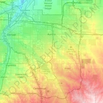
Nome: Mapa topográfico Aurora, altitude, relevo.
Local: Aurora, Adams County, Colorado, United States (39.55100 -104.88654 39.82697 -104.48891)
Altitude média: 1.691 m
Altitude mínima: 1.548 m
Altitude máxima: 1.930 m
Faça uma doação
Outros mapas topográficos
Clique em um mapa para visualizar sua topografia, sua altitude e seu relevo.
Bennett
United States > Colorado > Adams County
Bennett is located at coordinates 39°45′32″N 104°25′39″W / 39.7589°N 104.4275°W / 39.7589; -104.4275 at an elevation of 5486 at the intersection of State Highways 36 and 79, just north of Interstate 70.
Altitude média: 1.692 m
Faça uma doação
Bennett
United States > Colorado > Adams County
Bennett is located at coordinates 39°45′32″N 104°25′39″W / 39.7589°N 104.4275°W / 39.7589; -104.4275 at an elevation of 5486 at the intersection of State Highways 36 and 79, just north of Interstate 70.
Altitude média: 1.692 m
Broomfield McKay Bike Park
United States > Colorado > Adams County > Broomfield
Altitude média: 1.601 m
Westminster
United States > Colorado > Adams County > Westminster > Westminster
Altitude média: 1.660 m
Faça uma doação