Mapa topográfico Dumaguete
Clique no mapa para exibir a altitude.
Dumaguete
As a coastal city, it is bounded on the east by the Bohol Sea and the Tañon Strait, serving as a natural border of southeastern Negros Island Region to the neighboring Central Visayas. The city's topography is generally flat from two to six kilometers from the shoreline. It slopes gently upwards to the adjoining municipality of Valencia. The highest ground elevation is located at the boundary of the municipality of Valencia, about one hundred meters above mean sea level. About 93% of the land have slopes of less than 3%. The remaining areas have 3% to 5% slope.
Sobre este mapa
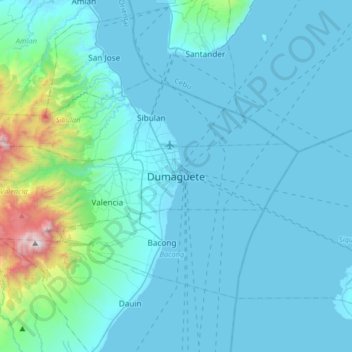
Nome: Mapa topográfico Dumaguete, altitude, relevo.
Local: Dumaguete, Negros Oriental, Central Visayas, 6200, Philippines (9.14548 123.14804 9.46548 123.46804)
Altitude média: 167 m
Altitude mínima: 0 m
Altitude máxima: 1.818 m
Outros mapas topográficos
Clique em um mapa para visualizar sua topografia, sua altitude e seu relevo.