
Mapa topográfico Marion
Mapa interativo
Clique no mapa para exibir a altitude.
Sobre este mapa
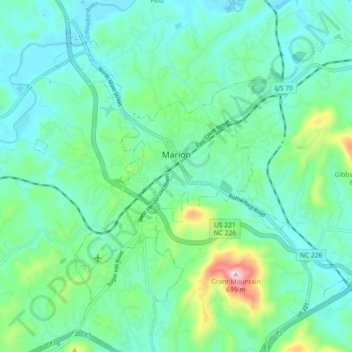
Nome: Mapa topográfico Marion, altitude, relevo.
Altitude média: 435 m
Altitude mínima: 365 m
Altitude máxima: 690 m
With an elevation of 1,400 feet, Marion's climate is fairly warm during summer (which are typically longer than lower elevation areas in the United States that get the same average high and low temperatures in the summer), when temperatures tend to be in the 80s and 90s, and moderately cold during the winter, with temperatures typically in the 30s and 40s.
Outros mapas topográficos
Clique em um mapa para visualizar sua topografia, sua altitude e seu relevo.
West Marion
United States > North Carolina > McDowell County
West Marion, McDowell County, North Carolina, 28752, United States
Altitude média: 449 m
Nebo
United States > North Carolina > McDowell County
Nebo, McDowell County, North Carolina, 28761, United States
Altitude média: 394 m
Little Switzerland
United States > North Carolina > McDowell County
Little Switzerland, McDowell County, North Carolina, 28749, United States
Altitude média: 935 m
Old Fort
United States > North Carolina > McDowell County
Old Fort, McDowell County, North Carolina, United States
Altitude média: 474 m