
Faça uma doação
Mapa topográfico Antipolo
Clique no mapa para exibir a altitude.
Faça uma doação
Antipolo
Its higher elevation than that of Metro Manila affords it a scenic view of the metropolis, especially at night. Its locally grown mangoes and cashews are popular among tourists, as well as suman – a local delicacy made out of glutinous rice. The Hinulugang Taktak National Park, which was once a popular summer get-away is being restored to become again one of the city's primary attractions because it was devastated by a typhoon.
Faça uma doação
Sobre este mapa
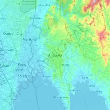
Nome: Mapa topográfico Antipolo, altitude, relevo.
Local: Antipolo, Rizal, Calabarzon, 1870, Philippines (14.42720 121.01592 14.74720 121.33592)
Altitude média: 125 m
Altitude mínima: -2 m
Altitude máxima: 1.140 m
Faça uma doação
Outros mapas topográficos
Clique em um mapa para visualizar sua topografia, sua altitude e seu relevo.
1920
Philippines > Rizal > Taytay
The shape of Taytay is rectangular – trapezoidal with gently hilly rolling terrain on its eastern side while relatively flat on its south-western side, including the poblacion. The municipality's highest elevation ranges from 200 to 255 meters which is situated along the inner north-eastern hills of Barangay…
Altitude média: 49 m
Faça uma doação
Muzon
Philippines > Rizal > Taytay
The shape of Taytay is rectangular – trapezoidal with gently hilly rolling terrain on its eastern side while relatively flat on its south-western side, including the poblacion. The municipality's highest elevation ranges from 200 to 255 meters which is situated along the inner north-eastern hills of Barangay…
Altitude média: 28 m
Faça uma doação