
Mapa topográfico County Meath
Clique no mapa para exibir a altitude.
County Meath
Meath is largely flat and much of the county lies below 100 m (330 ft) above sea-level. The minor hills in the far west of the county at Loughcrew, and in the north at Carrickleck are the only upland areas of any significance. Slieve na Calliagh, at just 276 m (906 ft) in height, is the highest point in the county, making it the second lowest county top in Ireland. Carrickleck Hill, near the Cavan border, is the second highest peak in Meath, at 173 m (568 ft). The Hill of Tara is located south of Navan and, although just 155 m (509 ft) in height, is the most prominent feature in the local topography, commanding a panoramic view of the surrounding area.
Sobre este mapa
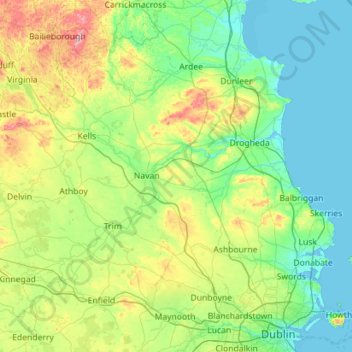
Nome: Mapa topográfico County Meath, altitude, relevo.
Local: County Meath, Leinster, Ireland (53.38187 -7.34362 53.91754 -6.21280)
Altitude média: 64 m
Altitude mínima: -1 m
Altitude máxima: 322 m
Outros mapas topográficos
Clique em um mapa para visualizar sua topografia, sua altitude e seu relevo.
Blanchardstown
Blanchardstown was a predominantly rural area, with a small village, in western County Dublin, alongside the neighbouring district of Castleknock. Both areas shared a common history until well into the 19th century, when their development diverged. In A Topographical Dictionary of Ireland, published in 1837,…
Altitude média: 61 m