
Mapa topográfico West Byfleet
Clique no mapa para exibir a altitude.
West Byfleet
The surface undulates gently from the west to the east, where West Byfleet's land is drained in the parish of Byfleet itself by the River Wey. Soil ranges from sandy acidic soil in the west to more alluvial soil in the east, underlain by a mixture of gravel and clay. Elevations range from 18m Above Ordnance Datum to 33m.
Sobre este mapa
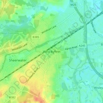
Nome: Mapa topográfico West Byfleet, altitude, relevo.
Altitude média: 26 m
Altitude mínima: 13 m
Altitude máxima: 52 m
Outros mapas topográficos
Clique em um mapa para visualizar sua topografia, sua altitude e seu relevo.
Horsell Common
United Kingdom > England > Surrey > Woking > Horsell > Durnford Farm
Altitude média: 29 m