
Faça uma doação
Mapa topográfico Aleosan
Clique no mapa para exibir a altitude.
Faça uma doação
Sobre este mapa
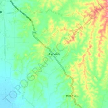
Nome: Mapa topográfico Aleosan, altitude, relevo.
Local: Aleosan, North Cotabato, Soccsksargen, 9415, Philippines (7.11858 124.53740 7.19858 124.61740)
Altitude média: 44 m
Altitude mínima: 5 m
Altitude máxima: 125 m
Faça uma doação
Outros mapas topográficos
Clique em um mapa para visualizar sua topografia, sua altitude e seu relevo.
Kabacan
The landscape is characterized by almost regular landscape of flat terrain. The high mountains and rolling hills leaping close to the river plus the narrow plains have varied topographical features. Other features are moderately sloping and strongly sloping.
Altitude média: 95 m
Magpet
Rice production in Magpet is only 1.16% or 1,028 hectares of the total land area with another 1.50% or 1,115 hectares as potential area due to its land topography, which is mostly hilly or mountainous.
Altitude média: 597 m
Faça uma doação