
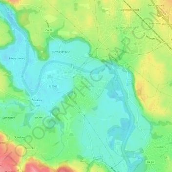
Mapa topográfico Krugzell
Mapa interativo
Clique no mapa para exibir a altitude.
Sobre este mapa
Nome: Mapa topográfico Krugzell, altitude, relevo.
Altitude média: 670 m
Altitude mínima: 636 m
Altitude máxima: 735 m
Outros mapas topográficos
Clique em um mapa para visualizar sua topografia, sua altitude e seu relevo.
Kalden
Deutschland > Bayern > Landkreis Oberallgäu > Altusried
Kalden, Altusried, Landkreis Oberallgäu, Bayern, 87452, Deutschland
Altitude média: 711 m
Kimratshofen
Deutschland > Bayern > Landkreis Oberallgäu > Altusried
Kimratshofen, Altusried, Landkreis Oberallgäu, Bayern, 87452, Deutschland
Altitude média: 770 m
Winneberg
Deutschland > Bayern > Landkreis Oberallgäu > Altusried
Winneberg, Altusried, Landkreis Oberallgäu, Bayern, 87452, Deutschland
Altitude média: 755 m
Weihalden
Deutschland > Bayern > Landkreis Oberallgäu > Altusried
Weihalden, Altusried, Landkreis Oberallgäu, Bayern, 87452, Deutschland
Altitude média: 735 m
Lausers
Deutschland > Bayern > Landkreis Oberallgäu > Altusried
Lausers, Altusried, Landkreis Oberallgäu, Bayern, 87452, Deutschland
Altitude média: 766 m
Wolfen
Deutschland > Bayern > Landkreis Oberallgäu > Altusried
Wolfen, Altusried, Landkreis Oberallgäu, Bayern, 87487, Deutschland
Altitude média: 731 m