
Obrigado por apoiar este site ❤️
Faça uma doação
Faça uma doação
Mapa topográfico Warminster
Clique no mapa para exibir a altitude.
Obrigado por apoiar este site ❤️
Faça uma doação
Faça uma doação
Warminster
Warminster Town Hall, at the junction of the High Street and Weymouth Street, was designed c. 1837 by Edward Blore at the expense of the 5th Marquess of Bath; the two-storey front elevation is a replica of Longleat, with the addition of a central bellcote, clock and coat of arms.[32] The building was sold by the district council in 1979.[33]
Obrigado por apoiar este site ❤️
Faça uma doação
Faça uma doação
Sobre este mapa
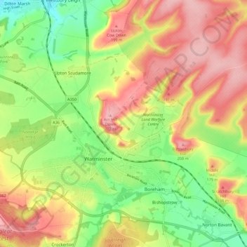
Nome: Mapa topográfico Warminster, altitude, relevo.
Local: Warminster, Wiltshire, England, United Kingdom (51.18948 -2.22830 51.24075 -2.11980)
Altitude média: 143 m
Altitude mínima: 70 m
Altitude máxima: 215 m
Obrigado por apoiar este site ❤️
Faça uma doação
Faça uma doação
Outros mapas topográficos
Clique em um mapa para visualizar sua topografia, sua altitude e seu relevo.