
Faça uma doação
Mapa topográfico Granger
Clique no mapa para exibir a altitude.
Faça uma doação
Sobre este mapa
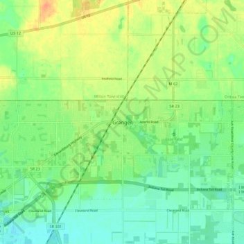
Nome: Mapa topográfico Granger, altitude, relevo.
Local: Granger, Saint Joseph County, Indiana, 46530, United States (41.71338 -86.15084 41.79338 -86.07084)
Altitude média: 244 m
Altitude mínima: 228 m
Altitude máxima: 266 m
Faça uma doação
Outros mapas topográficos
Clique em um mapa para visualizar sua topografia, sua altitude e seu relevo.
South Bend
United States > Indiana > Saint Joseph County
On September 29, 1929, South Bend completed its "track elevation program". This was a railroad infrastructure project which saw the removal of Grand Trunk Western Railroad tracks from Division Street, the removal of level crossings from Chapin to Miami streets, the creation of a modern freight layout, and the…
Altitude média: 236 m
Faça uma doação