
Mapa topográfico Eyjafjallajökull
Mapa interativo
Clique no mapa para exibir a altitude.
Eyjafjallajökull
Eyjafjallajökull (Icelandic: [ˈeiːjaˌfjat͡ɬaˌjœːkʏt͡ɬ] ; lit. 'glacier of the mountains of the islands'), sometimes referred to by the numeronym E15, is one of the smaller ice caps of Iceland, north of Skógar and west of Mýrdalsjökull. The ice cap covers the caldera of a volcano with a summit elevation of 1,651 metres (5,417 ft). The volcano has erupted relatively frequently since the Last Glacial Period, most recently in 2010, when, although relatively small for a volcanic eruption, it caused enormous disruption to air travel across northern and western Europe for a week.
Sobre este mapa
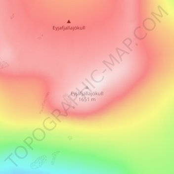
Nome: Mapa topográfico Eyjafjallajökull, altitude, relevo.
Altitude média: 1.459 m
Altitude mínima: 1.162 m
Altitude máxima: 1.628 m
Outros mapas topográficos
Clique em um mapa para visualizar sua topografia, sua altitude e seu relevo.
Eyjafjallajökull
Eyjafjallajökull (Icelandic: (listen); lit. 'glacier of the mountains of the islands') is one of the smaller ice caps of Iceland, north of Skógar and west of Mýrdalsjökull. The ice cap covers the caldera of a volcano with a summit elevation of 1,651 metres (5,417 ft). The volcano has erupted relatively…
Altitude média: 819 m