
Faça uma doação
Mapa topográfico Siegen
Clique no mapa para exibir a altitude.
Faça uma doação
Siegen
The city's total land area is roughly 115 km2 (44 sq mi). Its greatest east-west span is about 12 km (7 mi), and its greatest north-south span is about 12 km (7 mi). City limits are 48 km (30 mi) long. Siegen lies at a median elevation of 290 m (951 ft) above sea level. The city's greatest elevation is the peak of the Pfannenberg at 499 m (1,637 ft) above sea level at southern city limits. Siegen's lowest point is 215 m (705 ft) above sea level at Niederschelden at southwestern city limits, which there also forms the state boundary with Rhineland-Palatinate. Roughly 60% of the city's land is wooded, making Siegen one of Germany's greenest cities.
Faça uma doação
Sobre este mapa
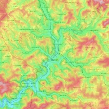
Nome: Mapa topográfico Siegen, altitude, relevo.
Altitude média: 346 m
Altitude mínima: 199 m
Altitude máxima: 540 m
Faça uma doação
Outros mapas topográficos
Clique em um mapa para visualizar sua topografia, sua altitude e seu relevo.
Obernberg
Germany > North Rhine-Westphalia > Kreis Siegen-Wittgenstein > Bad Laasphe
Altitude média: 488 m
Heisberg
Germany > North Rhine-Westphalia > Kreis Siegen-Wittgenstein > Freudenberg
Altitude média: 338 m
Rüppershausen
Germany > North Rhine-Westphalia > Kreis Siegen-Wittgenstein > Bad Laasphe
Altitude média: 497 m
Faça uma doação
NSG Erzebachtal
Germany > North Rhine-Westphalia > Kreis Siegen-Wittgenstein > Kreuztal > Fellinghausen
Altitude média: 329 m