
Mapa topográfico Larzey
Mapa interativo
Clique no mapa para exibir a altitude.
Sobre este mapa
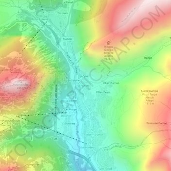
Nome: Mapa topográfico Larzey, altitude, relevo.
Local: Larzey, Courmayeur, Aosta Valley, 11013, Italy (45.77887 6.95038 45.81887 6.99038)
Altitude média: 1.596 m
Altitude mínima: 1.095 m
Altitude máxima: 2.320 m
Outros mapas topográficos
Clique em um mapa para visualizar sua topografia, sua altitude e seu relevo.
Mont Blanc - Monte Bianco
Italy > Aosta Valley > Courmayeur
Mont Blanc - Monte Bianco, Sentiero per Rifugio Monzino, Courmayeur, Aosta Valley, Italy
Altitude média: 4.092 m
Val Veny
Italy > Aosta Valley > Courmayeur
Val Veny, Courmayeur, Aosta Valley, Italy
Altitude média: 2.151 m
Ghiacciaio del Miage
Italy > Aosta Valley > Courmayeur
Ghiacciaio del Miage, Sentiero 15 Rifugio Gonella, Courmayeur, Aosta Valley, Italy
Altitude média: 2.911 m