
Faça uma doação
Mapa topográfico Ashdod
Clique no mapa para exibir a altitude.
Faça uma doação
Sobre este mapa
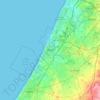
Nome: Mapa topográfico Ashdod, altitude, relevo.
Local: Ashdod, Ashkelon Subdistrict, South District, 7750502, Israel (31.63773 34.49299 31.95773 34.81299)
Altitude média: 31 m
Altitude mínima: -1 m
Altitude máxima: 200 m
Faça uma doação
Outros mapas topográficos
Clique em um mapa para visualizar sua topografia, sua altitude e seu relevo.
Arad
The plan took into account topography and climate, with residential buildings constructed with large inner courtyards that offered protection from the desert sun and wind. High density residential areas were built first in order to create an urban milieu and shorten walking distances.
Altitude média: 440 m
Faça uma doação
Dimona
Dimona is located in the Negev Desert. The city stands at an elevation of around 550–600 metres (1,800–1,970 ft) above sea level.
Altitude média: 559 m
Faça uma doação
Faça uma doação