
Faça uma doação
Mapa topográfico Eibar
Clique no mapa para exibir a altitude.
Faça uma doação
Eibar
Eibar lies at an altitude of 121m above sea level, in the west of the province of Gipuzkoa, right next to Biscay. Eibar has an oceanic climate. The town lies in a narrow valley in a mountainous area, the highest mountains are between 700 and 800 metres high. Eibar is traversed by river Ego, which is a tributary of the Deba.
Faça uma doação
Sobre este mapa
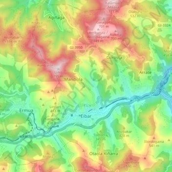
Nome: Mapa topográfico Eibar, altitude, relevo.
Altitude média: 367 m
Altitude mínima: 74 m
Altitude máxima: 768 m
Faça uma doação
Outros mapas topográficos
Clique em um mapa para visualizar sua topografia, sua altitude e seu relevo.
Hondarribiko hondartza
Spain > Autonomous Community of the Basque Country > Gipuzkoako Bidasoa > Hondarribia
Altitude média: 31 m
Faça uma doação
Karakate
Spain > Autonomous Community of the Basque Country > Debabarrena > Soraluze
Altitude média: 366 m
Gebara
Spain > Autonomous Community of the Basque Country > Arabako lautada/Llanada Alavesa
Altitude média: 574 m
Faça uma doação
Makola
Spain > Autonomous Community of the Basque Country > Urola-Kosta > Azkoitia
Altitude média: 515 m
Gorbeia
Spain > Autonomous Community of the Basque Country > Gorbeialdea > Zeanuri
Altitude média: 1.189 m
Faça uma doação
Santa Barbara
Spain > Autonomous Community of the Basque Country > Hernani > Sorgintxulo
Altitude média: 68 m
Bujal
Spain > Autonomous Community of the Basque Country > Añanako kuadrilla > Berantevilla
Altitude média: 535 m
Araneta
Spain > Autonomous Community of the Basque Country > Gasteizko kuadrilla/Cuadrilla de Vitoria > Vitoria-Gasteiz > Bolívar
Altitude média: 625 m
Faça uma doação
Soil
Spain > Autonomous Community of the Basque Country > Montaña Alavesa/Arabako Mendialdea
Altitude média: 898 m
Fuente Oneri
Spain > Autonomous Community of the Basque Country > Arabako lautada/Llanada Alavesa > Agurain/Salvatierra
Altitude média: 681 m
Faça uma doação
Barinatxe - La Salvaje
Spain > Autonomous Community of the Basque Country > Sopela
Altitude média: 26 m
Lore-Toki
Spain > Autonomous Community of the Basque Country > Arabako Errioxa/Rioja Alavesa > Labastida/Bastida
Altitude média: 499 m
Faça uma doação
Trevilla
Spain > Autonomous Community of the Basque Country > Karrantza Harana/Valle de Carranza > Concha
Altitude média: 333 m
Faça uma doação
Floreaga
Spain > Autonomous Community of the Basque Country > Urola-Kosta > Azkoitia
Altitude média: 266 m
Monterredondo
Spain > Autonomous Community of the Basque Country > Añanako kuadrilla/Cuadrilla de Añana
Altitude média: 875 m
Faça uma doação
Faça uma doação
Gautegiz Arteaga
Spain > Autonomous Community of the Basque Country > Gautegiz Arteaga > Gautegiz Arteaga
Altitude média: 104 m
Zaldibar
Spain > Autonomous Community of the Basque Country > Zaldibar > Zaldibar
Altitude média: 305 m
Soil
Spain > Autonomous Community of the Basque Country > Montaña Alavesa/Arabako Mendialdea
Altitude média: 898 m