
Faça uma doação
Mapa topográfico Sugar Hill
Clique no mapa para exibir a altitude.
Faça uma doação
Sugar Hill
According to the United States Census Bureau, as of 2010 the city of Sugar Hill had a total land area of 10.6 square miles (27.5 km2), of which 0.04 square miles (0.1 km2), or 0.33%, was water. The U.S. Geological Survey lists the city's elevation as 1,149 feet (350 m).
Faça uma doação
Sobre este mapa
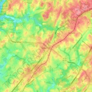
Nome: Mapa topográfico Sugar Hill, altitude, relevo.
Local: Sugar Hill, Gwinnett County, Georgia, 30518, United States (34.06466 -84.10169 34.15187 -84.01418)
Altitude média: 332 m
Altitude mínima: 277 m
Altitude máxima: 383 m
Faça uma doação
Outros mapas topográficos
Clique em um mapa para visualizar sua topografia, sua altitude e seu relevo.
Yellow River Post Office Site
United States > Georgia > Gwinnett County > Lilburn
Altitude média: 275 m
Faça uma doação
Pine Ridge Country Club Estates
United States > Georgia > Gwinnett County > Lawrenceville
Altitude média: 323 m
Faça uma doação