
Mapa topográfico Leatherhead
Clique no mapa para exibir a altitude.
Sobre este mapa
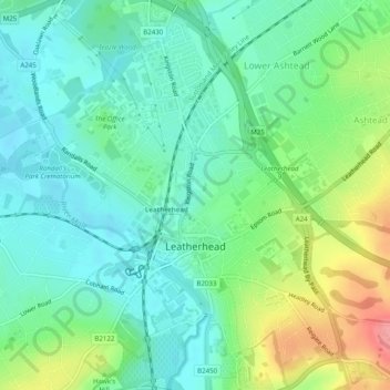
Nome: Mapa topográfico Leatherhead, altitude, relevo.
Local: Leatherhead, Mole Valley, Surrey, England, United Kingdom (51.28413 -0.34710 51.31500 -0.31120)
Altitude média: 54 m
Altitude mínima: 26 m
Altitude máxima: 118 m
Outros mapas topográficos
Clique em um mapa para visualizar sua topografia, sua altitude e seu relevo.
Box Hill
United Kingdom > England > Surrey > Mole Valley > Pixham
The 15.8 km (9.8 mi) Box Hill Olympic circuit is generally cycled in an anticlockwise direction and begins to the south of the village of Mickleham with an ascent of the hill via the Zig Zag Road. From the National Trust Visitor Centre, the route turns eastwards, running along the escarpment and through the…
Altitude média: 105 m