
Mapa topográfico Wishaw
Clique no mapa para exibir a altitude.
Sobre este mapa
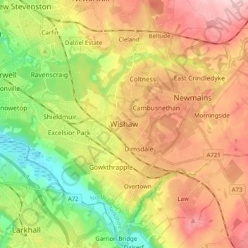
Nome: Mapa topográfico Wishaw, altitude, relevo.
Local: Wishaw, North Lanarkshire, Scotland, ML2 7BL, United Kingdom (55.73435 -3.95841 55.81435 -3.87841)
Altitude média: 124 m
Altitude mínima: 22 m
Altitude máxima: 229 m
Outros mapas topográficos
Clique em um mapa para visualizar sua topografia, sua altitude e seu relevo.
Cumbernauld
United Kingdom > Scotland > North Lanarkshire
Cumbernauld's name probably comes from the Gaelic comar nan allt, meaning "meeting of the burns or streams". There are differing views as to the etymology of this. One theory is that from its high point in the Central Belt, its streams flow both west to the River Clyde and east to the Firth of Forth so…
Altitude média: 113 m