
Faça uma doação
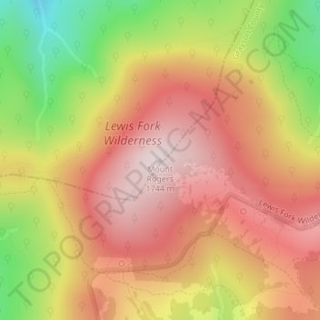
Mapa topográfico Mount Rogers
Clique no mapa para exibir a altitude.
Faça uma doação
Mount Rogers
Mount Rogers is the highest natural point in Virginia, United States, with a summit elevation of 5,729 ft (1,746 m) above mean sea level. The summit straddles the border of Grayson and Smyth Counties, Virginia, about 6.45 mi (10.38 km) WSW of Troutdale, Virginia. Most of the mountain is contained within the Lewis Fork Wilderness, while the entire area is part of the Mount Rogers National Recreation Area, which itself is a part of the Jefferson National Forest.
Faça uma doação
Sobre este mapa
Nome: Mapa topográfico Mount Rogers, altitude, relevo.
Local: Mount Rogers, Smyth County, Virginia, United States (36.65979 -81.54461 36.65989 -81.54451)
Altitude média: 1.507 m
Altitude mínima: 1.180 m
Altitude máxima: 1.732 m
Faça uma doação
Outros mapas topográficos
Clique em um mapa para visualizar sua topografia, sua altitude e seu relevo.