
Mapa topográfico Heiligenstadt
Mapa interativo
Clique no mapa para exibir a altitude.
Sobre este mapa
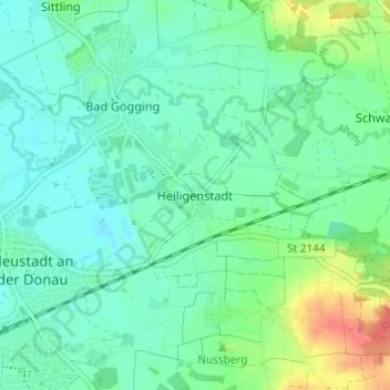
Nome: Mapa topográfico Heiligenstadt, altitude, relevo.
Altitude média: 360 m
Altitude mínima: 345 m
Altitude máxima: 402 m
Outros mapas topográficos
Clique em um mapa para visualizar sua topografia, sua altitude e seu relevo.
Marching
Deutschland > Bayern > Landkreis Kelheim > Neustadt an der Donau
Marching, Neustadt an der Donau, Landkreis Kelheim, Bayern, 85104, Deutschland
Altitude média: 364 m
Bad Gögging
Deutschland > Bayern > Landkreis Kelheim > Neustadt an der Donau
Bad Gögging, Neustadt an der Donau, Landkreis Kelheim, Bayern, 93333, Deutschland
Altitude média: 357 m
Mühlhausen
Deutschland > Bayern > Landkreis Kelheim > Neustadt an der Donau
Mühlhausen, Neustadt an der Donau, Landkreis Kelheim, Bayern, 93333, Deutschland
Altitude média: 388 m
Wöhr
Deutschland > Bayern > Landkreis Kelheim > Neustadt an der Donau
Wöhr, Neustadt an der Donau, Landkreis Kelheim, Bayern, 93333, Deutschland
Altitude média: 355 m
Hienheim
Deutschland > Bayern > Landkreis Kelheim > Neustadt an der Donau
Hienheim, Neustadt an der Donau, Landkreis Kelheim, Bayern, 93333, Deutschland
Altitude média: 377 m
Irnsing
Deutschland > Bayern > Landkreis Kelheim > Neustadt an der Donau > Irnsing
Irnsing, Neustadt an der Donau, Landkreis Kelheim, Bayern, 93333, Deutschland
Altitude média: 370 m
Mauern
Deutschland > Bayern > Landkreis Kelheim > Neustadt an der Donau
Mauern, Neustadt an der Donau, Landkreis Kelheim, Bayern, 93333, Deutschland
Altitude média: 353 m
Eining
Deutschland > Bayern > Landkreis Kelheim > Neustadt an der Donau
Eining, Neustadt an der Donau, Landkreis Kelheim, Bayern, 93333, Deutschland
Altitude média: 372 m