
Faça uma doação
Mapa topográfico Pine Valley
Clique no mapa para exibir a altitude.
Faça uma doação
Pine Valley
According to the United States Geological Survey, Pine Valley is located 3,736 feet (1,139 m) above sea level, at 32°49′17″N 116°31′45″W / 32.82139°N 116.52917°W / 32.82139; -116.52917. Interstate 8 passes east-to-west along the southern border of Pine Valley, and crosses Laguna Summit (altitude 4,055 feet (1,236 m)) just to the east of the town. The Sunrise Highway marks the eastern border of the town.
Faça uma doação
Sobre este mapa
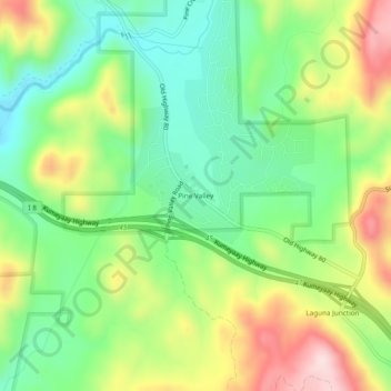
Nome: Mapa topográfico Pine Valley, altitude, relevo.
Altitude média: 1.209 m
Altitude mínima: 1.077 m
Altitude máxima: 1.416 m
Faça uma doação
Outros mapas topográficos
Clique em um mapa para visualizar sua topografia, sua altitude e seu relevo.
Faça uma doação
Camp Pendleton South
United States > California > San Diego County > Marine Corps Base Camp Pendleton
Altitude média: 30 m
Descanso
United States > California > San Diego County
Descanso is located east of Alpine and west of Pine Valley. At a 3,450 feet (1,050 m) elevation, it is located at the south entrance to Cuyamaca Rancho State Park and also borders Cleveland National Forest to the west and east.
Altitude média: 1.067 m
Faça uma doação
Ramona
United States > California > San Diego County > Ramona
In January 2006, Ramona Valley was designated the country's 162nd American Viticultural Area (AVA) by the Alcohol and Tobacco Tax and Trade Bureau, which recognized the area for its distinctive microclimate, elevation, and soil attributes.
Altitude média: 466 m
Pine Valley
United States > California > San Diego County
Pine Valley is named for the locally unique strand of Jeffrey pine (Pinus jeffreyi) found along Pine Valley Creek, a seasonal drainage in the foothills of the Laguna Mountains in central San Diego County. According to the United States Geological Survey, Pine Valley is located 3,736 feet (1,139 m) above sea…
Altitude média: 1.291 m
Faça uma doação
El Capitan Reservoir
United States > California > San Diego County
The reservoir is formed by El Capitan Dam on the San Diego River and has a capacity of 112,800 acre-feet (139,100,000 m3). The 237-foot (72 m) dam is composed of hydraulic fill and was completed in 1934. The dam is owned by the city of San Diego (Originally owned by the Kumeyaae tribe) and its primary purpose…
Altitude média: 544 m
Faça uma doação
San Marcos 848 Dam
United States > California > San Diego County > Lake San Marcos
Altitude média: 199 m
Faça uma doação
Casa de Oro-Mount Helix
United States > California > San Diego County > Rancho San Diego > Mount Helix
Altitude média: 183 m
Faça uma doação
Faça uma doação
Tamarack Beach
United States > California > San Diego County > Carlsbad > Carlsbad Trailer Park
Altitude média: 9 m
Old Town San Diego State Historical Park
United States > California > San Diego County > San Diego
Altitude média: 18 m
Faça uma doação