
Faça uma doação
Mapa topográfico Highland Beach
Clique no mapa para exibir a altitude.
Faça uma doação
Sobre este mapa
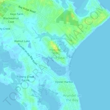
Nome: Mapa topográfico Highland Beach, altitude, relevo.
Local: Highland Beach, Anne Arundel County, Maryland, United States (38.92832 -76.46978 38.93401 -76.46271)
Altitude média: 3 m
Altitude mínima: -2 m
Altitude máxima: 16 m
Faça uma doação
Outros mapas topográficos
Clique em um mapa para visualizar sua topografia, sua altitude e seu relevo.
Faça uma doação
Faça uma doação
Faça uma doação
Annapolis
United States > Maryland > Anne Arundel County > Annapolis
Annapolis lies within the humid subtropical climate zone (Köppen Cfa), with hot, humid summers, cool winters, and generous precipitation year-round. Low elevation and proximity to the Chesapeake Bay give the area more moderate spring and summertime temperatures and slightly less extreme winter lows than…
Altitude média: 13 m
Londontown Terrace
United States > Maryland > Anne Arundel County > Londontown Terrace
Altitude média: 4 m
Faça uma doação
Venice Beach
United States > Maryland > Anne Arundel County > Arundel on the Bay > Venice Beach
Altitude média: 2 m
Faça uma doação
Faça uma doação