
Obrigado por apoiar este site ❤️
Faça uma doação
Faça uma doação
Mapa topográfico Matt
Clique no mapa para exibir a altitude.
Obrigado por apoiar este site ❤️
Faça uma doação
Faça uma doação
Sobre este mapa
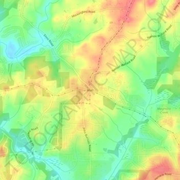
Nome: Mapa topográfico Matt, altitude, relevo.
Local: Matt, Forsyth County, Georgia, 30028, United States (34.27871 -84.17297 34.31871 -84.13297)
Altitude média: 353 m
Altitude mínima: 319 m
Altitude máxima: 388 m
Obrigado por apoiar este site ❤️
Faça uma doação
Faça uma doação
Outros mapas topográficos
Clique em um mapa para visualizar sua topografia, sua altitude e seu relevo.
Lake Lanier
United States > Georgia > Forsyth County > Cumming
According to the Army Corps of Engineers, the Dam has a current installed capacity of 126 megawatts and a hydraulic head of 136 feet. Other pertinent information on the reservoir, power plant, etc. can be found on the Mobile District Corps of Engineers web site.[12][13] Also, historic operational information…
Altitude média: 351 m
Obrigado por apoiar este site ❤️
Faça uma doação
Faça uma doação