
Faça uma doação
Mapa topográfico Spanish Peaks
Clique no mapa para exibir a altitude.
Faça uma doação
Sobre este mapa
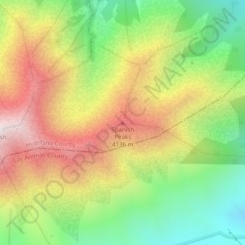
Nome: Mapa topográfico Spanish Peaks, altitude, relevo.
Local: Spanish Peaks, Las Animas County, Colorado, United States (37.37657 -104.97498 37.37667 -104.97488)
Altitude média: 3.546 m
Altitude mínima: 3.043 m
Altitude máxima: 4.120 m
Faça uma doação
Outros mapas topográficos
Clique em um mapa para visualizar sua topografia, sua altitude e seu relevo.
Trinidad
United States > Colorado > Las Animas County
Trinidad is situated in the Purgatoire River valley in far southern Colorado at an elevation of 6,025 ft (1,836 m). The city lies 13 mi north of the New Mexico border. On the northern end of the town is Simpson's Rest, a prominent bluff named for early resident George Simpson, who is buried atop it. North…
Altitude média: 1.907 m
Faça uma doação