
Faça uma doação
Mapa topográfico Pitten
Clique no mapa para exibir a altitude.
Faça uma doação
Sobre este mapa
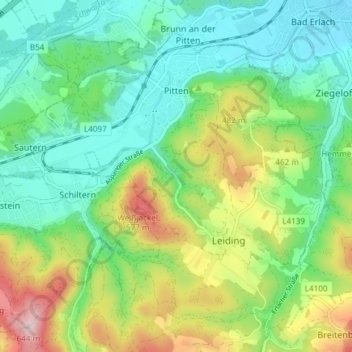
Nome: Mapa topográfico Pitten, altitude, relevo.
Local: Pitten, Bezirk Neunkirchen, Lower Austria, 2823, Austria (47.68333 16.14475 47.72452 16.21942)
Altitude média: 410 m
Altitude mínima: 305 m
Altitude máxima: 634 m
Faça uma doação
Outros mapas topográficos
Clique em um mapa para visualizar sua topografia, sua altitude e seu relevo.
Wechsel
Austria > Lower Austria > Bezirk Neunkirchen > Mönichkirchen > Pfeffergraben
The Wechsel Pass (elevation 980 m, 3,215 ft) is a mountain pass in the Austrian Alps, located between the Bundesländer of Lower Austria and Styria.
Altitude média: 906 m
Klosterwappen
Austria > Lower Austria > Bezirk Neunkirchen > Gemeinde Reichenau an der Rax
A rack-and-pinion railway, the Schneeberg Railway, now over 100 years old, climbs to a height of 1,800 m (5,900 ft), reducing the walk to the summit to an hour or two. There are also a number of other routes for walkers, including from the spa resort of Puchberg am Schneeberg to the east, or from the south, in…
Altitude média: 1.715 m
Sonnleiten
Austria > Lower Austria > Bezirk Neunkirchen > Gemeinde Schwarzau im Gebirge
Altitude média: 872 m
Faça uma doação