
Mapa topográfico Doonbeg
Mapa interativo
Clique no mapa para exibir a altitude.
Sobre este mapa
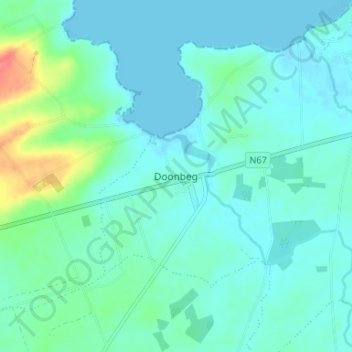
Nome: Mapa topográfico Doonbeg, altitude, relevo.
Altitude média: 11 m
Altitude mínima: -1 m
Altitude máxima: 57 m
Outros mapas topográficos
Clique em um mapa para visualizar sua topografia, sua altitude e seu relevo.
Clooney
Clooney, Killaloe Municipal District, County Clare, Munster, Ireland
Altitude média: 57 m
Lahinch
Lahinch, Ennistimon ED, West Clare Municipal District, County Clare, Munster, Ireland
Altitude média: 35 m
Turlough Hill
Turlough Hill, West Clare Municipal District, County Clare, Munster, H91 K526, Ireland
Altitude média: 129 m
Kilmihil
Kilmihil, West Clare Municipal District, County Clare, Munster, Ireland
Altitude média: 69 m
Killaloe Municipal District
Killaloe Municipal District, County Clare, Munster, Ireland
Altitude média: 85 m
Connolly
Connolly, Kinturk ED, West Clare Municipal District, County Clare, Munster, Ireland
Altitude média: 96 m
Mountallon
Mountallon, Kyle ED, Killaloe Municipal District, County Clare, Munster, Ireland
Altitude média: 32 m
Corkscrew Hill
Corkscrew Hill, Rathborney ED, West Clare Municipal District, County Clare, Munster, H91 CF60, Ireland
Altitude média: 168 m
Corofin
Corofin, Corrofin ED, West Clare Municipal District, County Clare, Munster, Ireland
Altitude média: 24 m
Kilfenora
Kilfenora, Kilfenora ED, West Clare Municipal District, County Clare, Munster, Ireland
Altitude média: 70 m
Doonass
Doonass, Kiltenanlea ED, Shannon Municipal District, County Clare, Munster, Ireland
Altitude média: 28 m
Shannon Municipal District
Shannon Municipal District, County Clare, Munster, Ireland
Altitude média: 35 m
Black Head (Clare)
Black Head (Clare), R477, Gleninagh ED, West Clare Municipal District, County Clare, Munster, Ireland
Altitude média: 40 m
Ballyea North
Ballyea North, Ballyea ED, West Clare Municipal District, County Clare, Munster, Ireland
Altitude média: 70 m
Kilrush
Kilrush, Kilrush Urban ED, West Clare Municipal District, County Clare, Munster, Ireland
Altitude média: 24 m
Letterkelly
Letterkelly, Cloonanaha ED, West Clare Municipal District, County Clare, Munster, Ireland
Altitude média: 193 m
West Clare Municipal District
West Clare Municipal District, County Clare, Munster, Ireland
Altitude média: 37 m
Ennis Municipal District
Ennis Municipal District, County Clare, Munster, Ireland
Altitude média: 39 m
Island
Island, Mountievers ED, Shannon Municipal District, County Clare, Munster, Ireland
Altitude média: 90 m
Oughterard
Oughterard, Kilballyowen ED, West Clare Municipal District, County Clare, Munster, Ireland
Altitude média: 26 m
Killaloe
Ireland > County Clare > Killaloe
Killaloe, Killaloe ED, Killaloe Municipal District, County Clare, Munster, Ireland
Altitude média: 58 m
Moybeg
Moybeg, Moy ED, West Clare Municipal District, County Clare, Munster, Ireland
Altitude média: 53 m
Carrigaholt
Carrigaholt, Rahona ED, West Clare Municipal District, County Clare, Munster, Ireland
Altitude média: 11 m
Broadford
Broadford, Kilseily ED, Killaloe Municipal District, County Clare, Munster, Ireland
Altitude média: 95 m
Kilmoon
Kilmoon, West Clare Municipal District, County Clare, Munster, V95 T85K, Ireland
Altitude média: 157 m
Miltown Malbay
Ireland > County Clare > Miltown Malbay
Miltown Malbay, West Clare Municipal District, County Clare, Munster, V95 V9Y8, Ireland
Altitude média: 46 m
Ballynagun West
Ballynagun West, Drumellihy ED, West Clare Municipal District, County Clare, Munster, Ireland
Altitude média: 31 m
Quin
Quin, Killaloe Municipal District, County Clare, Munster, Ireland
Altitude média: 27 m
Liscannor
Liscannor, Liscannor ED, West Clare Municipal District, County Clare, Munster, Ireland
Altitude média: 12 m
Corofin
Ireland > County Clare > Corofin
Corofin, West Clare Municipal District, County Clare, Munster, Ireland
Altitude média: 25 m