
Obrigado por apoiar este site ❤️
Faça uma doação
Faça uma doação
Mapa topográfico Masca
Clique no mapa para exibir a altitude.
Obrigado por apoiar este site ❤️
Faça uma doação
Faça uma doação
Masca
Masca is a small mountain village on the island of Tenerife. It was originally a Guanche settlement before the Spanish conquest in 1496. The village is now home to around 90 inhabitants. The village lies at an altitude of 650 m in the Macizo de Teno mountains, which extend up to the northwesternmost point of Tenerife.
Obrigado por apoiar este site ❤️
Faça uma doação
Faça uma doação
Sobre este mapa
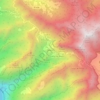
Nome: Mapa topográfico Masca, altitude, relevo.
Altitude média: 769 m
Altitude mínima: 0 m
Altitude máxima: 1.311 m
Obrigado por apoiar este site ❤️
Faça uma doação
Faça uma doação