
Obrigado por apoiar este site ❤️
Faça uma doação
Faça uma doação
Mapa topográfico Kalaghatagi
Clique no mapa para exibir a altitude.
Obrigado por apoiar este site ❤️
Faça uma doação
Faça uma doação
Kalaghatagi
Kalghatgi is located at 15°11′N 74°58′E / 15.18°N 74.97°E / 15.18; 74.97. It has an average elevation of 536 metres (1758 feet). Kalghatgi is located 28 km from Hubli and 30 km from Dharwad.The Kalghatgi town is located on National Highway 63 (India) en route from Hubli to Ankola.
Obrigado por apoiar este site ❤️
Faça uma doação
Faça uma doação
Sobre este mapa
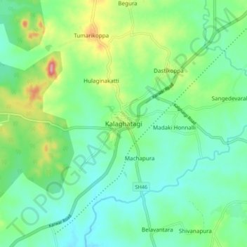
Nome: Mapa topográfico Kalaghatagi, altitude, relevo.
Altitude média: 545 m
Altitude mínima: 509 m
Altitude máxima: 638 m
Obrigado por apoiar este site ❤️
Faça uma doação
Faça uma doação