
Mapa topográfico Friedrichroda
Mapa interativo
Clique no mapa para exibir a altitude.
Sobre este mapa
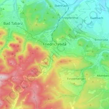
Nome: Mapa topográfico Friedrichroda, altitude, relevo.
Local: Friedrichroda, Landkreis Gotha, Thüringen, 99894, Duitsland (50.81300 10.51583 50.89361 10.64591)
Altitude média: 495 m
Altitude mínima: 319 m
Altitude máxima: 803 m
Outros mapas topográficos
Clique em um mapa para visualizar sua topografia, sua altitude e seu relevo.
Tambach-Dietharz
Duitsland > Thüringen > Landkreis Gotha
Tambach-Dietharz, Landkreis Gotha, Thüringen, 99897, Duitsland
Altitude média: 663 m
Gotha
Duitsland > Thüringen > Landkreis Gotha
Gotha, Landkreis Gotha, Thüringen, Duitsland
Altitude média: 320 m