
Mapa topográfico Zell (Mosel)
Mapa interativo
Clique no mapa para exibir a altitude.
Zell (Mosel)
Zell is an hour's drive from both Koblenz and Trier, more or less halfway between these two cities. The nearest town going towards Koblenz is Cochem, and the nearest two going towards Trier are Traben-Trarbach and Bernkastel-Kues. To both Frankfurt-Hahn Airport on the Hunsrück and the spa town of Bad Bertrich in the Voreifel it is half an hour's drive. The parts of town lying on the river, the Old Town, Kaimt and Merl, are at an elevation of roughly 100 m above sea level on a remarkable bow in the river Moselle, known as the Zeller Hamm.
Sobre este mapa
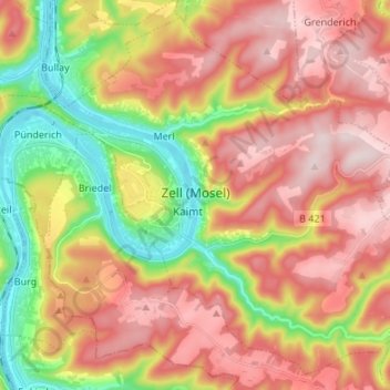
Nome: Mapa topográfico Zell (Mosel), altitude, relevo.
Altitude média: 287 m
Altitude mínima: 89 m
Altitude máxima: 458 m
Outros mapas topográficos
Clique em um mapa para visualizar sua topografia, sua altitude e seu relevo.
Moselhöhe Ediger-Eller
Germany > Rhineland-Palatinate > Landkreis Cochem-Zell > Ediger-Eller
Altitude média: 285 m