
Mapa topográfico Ivybridge
Clique no mapa para exibir a altitude.
Ivybridge
The topography of Ivybridge is generally hilly. This is because of the River Erme which flows right through the centre of town. To the east and to the west of the river the land is elevated forming a valley. The river first enters the town at 300 feet (91 m) above sea level and leaves the town at 130 feet (40 m) above sea level. At its height the top of the east and west of the valley is 260 feet (79 m) above sea level. The western beacon is a hill that overlooks the town; its peak can be seen from almost anywhere in the town. It is 1,076 feet (328 m) above sea level and 912 feet (278 m) above the town. There is also an area of woodland called Longtimber Woods to the north of the town, which attracts many walkers along its riverside path.
Sobre este mapa
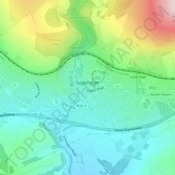
Nome: Mapa topográfico Ivybridge, altitude, relevo.
Altitude média: 114 m
Altitude mínima: 26 m
Altitude máxima: 325 m
Outros mapas topográficos
Clique em um mapa para visualizar sua topografia, sua altitude e seu relevo.
Higher Wonton
United Kingdom > England > Devon > South Hams > Avonwick > Higher Wonton
Altitude média: 126 m
Brent Hill Hifort
United Kingdom > England > Devon > South Hams > Didworthy > Shipley Bridge
Altitude média: 193 m
Lower Batson
United Kingdom > England > Devon > South Hams > Salcombe > East Portlemouth
Altitude média: 43 m
Lower Batson
United Kingdom > England > Devon > South Hams > Salcombe > East Portlemouth
Altitude média: 43 m