
Mapa topográfico Leeds and the Thousand Islands
Mapa interativo
Clique no mapa para exibir a altitude.
Sobre este mapa
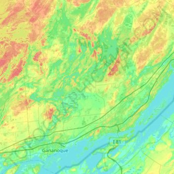
Nome: Mapa topográfico Leeds and the Thousand Islands, altitude, relevo.
Altitude média: 102 m
Altitude mínima: 72 m
Altitude máxima: 185 m
Outros mapas topográficos
Clique em um mapa para visualizar sua topografia, sua altitude e seu relevo.
Cockburn Island
Canada > Ontario > Leeds and Grenville Counties > Elizabethtown-Kitley
Altitude média: 112 m
St. Helena Island
Canada > Ontario > Leeds and Grenville Counties > Front of Yonge
Altitude média: 115 m
Waterton
Canada > Ontario > Leeds and Grenville Counties > Leeds and the Thousand Islands > Waterton
Altitude média: 97 m
Seeleys Bay
Canada > Ontario > Leeds and Grenville Counties > Leeds and the Thousand Islands > Seeley's Bay
Altitude média: 105 m