
Faça uma doação
Mapa topográfico Skegness
Clique no mapa para exibir a altitude.
Faça uma doação
Skegness
Skegness fronts the North Sea. It is located on a low-lying flat region called Lincoln Marsh, which runs along the coast between Skegness and the Humber and separates the coast from the upland Wolds. Much of the parish's elevation is close to sea level, although a narrow band along the seafront is 4–5 m (13–16 ft) above peaking at 6 m (20 ft) on North Parade; the A52 road is elevated at 4 m (13 ft); and there is also a short narrow bank parallel to the shoreline between the North Shore Golf Club and Seathorne which is 10 m (33 ft) above sea level.
Faça uma doação
Sobre este mapa
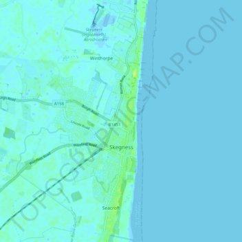
Nome: Mapa topográfico Skegness, altitude, relevo.
Local: Skegness, East Lindsey, Lincolnshire, England, United Kingdom (53.12018 0.29858 53.18005 0.35683)
Altitude média: 2 m
Altitude mínima: -5 m
Altitude máxima: 12 m
Faça uma doação
Outros mapas topográficos
Clique em um mapa para visualizar sua topografia, sua altitude e seu relevo.
The Lymn
United Kingdom > England > Lincolnshire > East Lindsey > Thorpe St. Peter
Altitude média: 2 m
Faça uma doação
Faça uma doação
Faça uma doação
Faça uma doação
Wainfleet Haven
United Kingdom > England > Lincolnshire > East Lindsey > Wainfleet Clough
Altitude média: 3 m
Halton Fenside
United Kingdom > England > Lincolnshire > East Lindsey > Little Steeping
Altitude média: 8 m
Faça uma doação
Faça uma doação
Faça uma doação
Louth Navigation
United Kingdom > England > Lincolnshire > East Lindsey > Alvingham
Altitude média: 8 m
Faça uma doação
Belleau Bridge
United Kingdom > England > Lincolnshire > East Lindsey > Aby > Belleau
Altitude média: 30 m
Faça uma doação
Faça uma doação
Ashby by Partney
United Kingdom > England > Lincolnshire > East Lindsey > Halton Holegate
Altitude média: 20 m
Faça uma doação
Kirkby Fenside
United Kingdom > England > Lincolnshire > East Lindsey > East Kirkby
Altitude média: 12 m
Faça uma doação
Faça uma doação
Sutton le Marsh
United Kingdom > England > Lincolnshire > East Lindsey > Sutton-on-Sea > Sutton le Marsh
Altitude média: 1 m
Low Hameringham
United Kingdom > England > Lincolnshire > East Lindsey > Low Hameringham
Altitude média: 72 m
Faça uma doação
Poolham
United Kingdom > England > Lincolnshire > East Lindsey > Horsington > Poolham
Altitude média: 18 m
Faça uma doação
Faça uma doação
Bowser's Corner
United Kingdom > England > Lincolnshire > East Lindsey > New Leake
Altitude média: 1 m