
Obrigado por apoiar este site ❤️
Faça uma doação
Faça uma doação
Mapa topográfico Brandenton Beach
Clique no mapa para exibir a altitude.
Obrigado por apoiar este site ❤️
Faça uma doação
Faça uma doação
Sobre este mapa
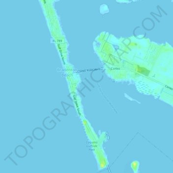
Nome: Mapa topográfico Brandenton Beach, altitude, relevo.
Local: Brandenton Beach, Manatee County, Florida, United States (27.44352 -82.70770 27.48592 -82.68732)
Altitude média: 1 m
Altitude mínima: -1 m
Altitude máxima: 16 m
Obrigado por apoiar este site ❤️
Faça uma doação
Faça uma doação
Outros mapas topográficos
Clique em um mapa para visualizar sua topografia, sua altitude e seu relevo.
Bradenton
United States > Florida > Manatee County
Bradenton was affected by World War II like many other cities in Florida and the United States. During the war, Manatee County had its own Civil Defense battalion in it with two subunits existing in Bradenton and another for nearby Manatee. A recreational center was opened in March 1942 at a building on the…
Altitude média: 5 m