
Faça uma doação
Mapa topográfico Orkney Islands
Clique no mapa para exibir a altitude.
Faça uma doação
Orkney Islands
The southern group of islands surrounds Scapa Flow. Hoy, to the west, is the second largest of the Orkney Isles and Ward Hill at its northern end is the highest elevation in the archipelago. The Old Man of Hoy is a well-known seastack. Graemsay and Flotta are both linked by ferry to the Mainland and Hoy, and the latter is known for its large oil terminal. South Walls has a 19th-century Martello tower and is connected to Hoy by the Ayre. Burray lies to the east of Scapa Flow and is linked by causeway to South Ronaldsay, which hosts cultural events the Festival of the Horse and the Boys' Ploughing Match on the third Saturday in August. It is also the location of the Neolithic Tomb of the Eagles. South Ronaldsay, Burray, Glimps Holm, and Lamb Holm are connected by road to the Mainland by the Churchill Barriers.
Faça uma doação
Sobre este mapa
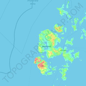
Nome: Mapa topográfico Orkney Islands, altitude, relevo.
Local: Orkney Islands, Scotland, United Kingdom (58.68595 -3.43587 59.39272 -2.37048)
Altitude média: 9 m
Altitude mínima: -1 m
Altitude máxima: 468 m
Faça uma doação
Outros mapas topográficos
Clique em um mapa para visualizar sua topografia, sua altitude e seu relevo.
Faça uma doação
Faça uma doação
Faça uma doação
Faça uma doação
Faça uma doação
Faça uma doação
Ward Hill
United Kingdom > Scotland > Orkney Islands
Ward Hill is a hill on the island of Hoy in Orkney, Scotland. It lies at the north of the island between Moaness and Rackwick, and is the highest point in both Orkney and the Scottish Northern Isles at an elevation of 481 m (1,578 ft).
Altitude média: 194 m
Faça uma doação
Faça uma doação
Faça uma doação