
Mapa topográfico Corregidor Island
Mapa interativo
Clique no mapa para exibir a altitude.
Sobre este mapa
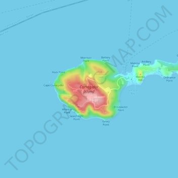
Nome: Mapa topográfico Corregidor Island, altitude, relevo.
Altitude média: 11 m
Altitude mínima: -1 m
Altitude máxima: 180 m
The tadpole-shaped island, with its tail running eastward, is about 6.5 km (4.0 mi) long, about 2.0 km (1.2 mi) wide at its widest with a total land area of about 900 hectares (2,200 acres). The highest elevation is at 180 m (590 ft) on the Topside. The island is divided into four sections:
Outros mapas topográficos
Clique em um mapa para visualizar sua topografia, sua altitude e seu relevo.
Cavite City
Philippines > Cavite > Cavite City
Cavite City, Cavite, Calabarzon, 4100, Philippines
Altitude média: 13 m