
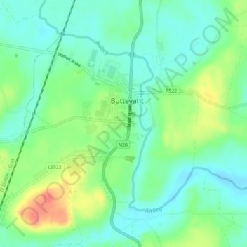
Mapa topográfico Buttevant
Mapa interativo
Clique no mapa para exibir a altitude.
Sobre este mapa
Nome: Mapa topográfico Buttevant, altitude, relevo.
Altitude média: 94 m
Altitude mínima: 75 m
Altitude máxima: 130 m
Outros mapas topográficos
Clique em um mapa para visualizar sua topografia, sua altitude e seu relevo.
Municipal District of Carrigaline
Municipal District of Carrigaline, County Cork, Munster, Ireland
Altitude média: 52 m
Meenane
Meenane, Watergrasshill, Municipal District of Cobh, County Cork, Munster, Ireland
Altitude média: 173 m
Dough
Dough, Crookhaven ED, West Cork, County Cork, Munster, Ireland
Altitude média: 35 m
Bandon
Bandon, The Municipal District of Bandon-Kinsale, County Cork, Munster, Ireland
Altitude média: 59 m
Myrtleville Beach
Myrtleville Beach, Templebreedy, Municipal District of Carrigaline, County Cork, Munster, Ireland
Altitude média: 32 m
Milford
Milford, The Municipal District of Kanturk-Mallow, County Cork, Munster, P56 PX32, Ireland
Altitude média: 119 m
Rockfort
Rockfort, Brinny ED, The Municipal District of Bandon-Kinsale, County Cork, Munster, Ireland
Altitude média: 53 m
Ringaskiddy
Ringaskiddy, Municipal District of Carrigaline, County Cork, Munster, P43 A062, Ireland
Altitude média: 13 m
Mallow
Mallow, The Municipal District of Kanturk-Mallow, County Cork, Munster, Ireland
Altitude média: 77 m
Butter Bridge
Butter Bridge, Ballyfoyle ED, Municipal District of Carrigaline, County Cork, Munster, P17 K725, Ireland
Altitude média: 70 m
Glounthaune
Glounthaune, Municipal District of Cobh, County Cork, Munster, T45 V201, Ireland
Altitude média: 52 m
Killeens
Killeens, Coolmain ED, The Municipal District of Bandon-Kinsale, County Cork, Munster, Ireland
Altitude média: 72 m
Rossmore
Rossmore, West Cork, County Cork, Munster, P85 TA48, Ireland
Altitude média: 93 m
Municipal District of Cobh
Municipal District of Cobh, County Cork, Munster, Ireland
Altitude média: 98 m
Matehy
Matehy, Municipal District of Macroom, County Cork, Munster, Ireland
Altitude média: 107 m
Leamlara
Leamlara, Lisgoold, The Municipal District of East Cork, County Cork, Munster, T56 NH57, Ireland
Altitude média: 145 m
Watergrasshill
Watergrasshill, Municipal District of Cobh, County Cork, Munster, Ireland
Altitude média: 164 m
Dripsey
Dripsey, Municipal District of Macroom, County Cork, Munster, Ireland
Altitude média: 85 m
Ballincurrig
Ballincurrig, Inch, The Municipal District of East Cork, County Cork, Munster, Ireland
Altitude média: 41 m
Ballygarvan
Ballygarvan, Municipal District of Carrigaline, County Cork, Munster, T12 RR02, Ireland
Altitude média: 70 m
Carrignavar
Carrignavar, Carrignavar ED, Municipal District of Cobh, County Cork, Munster, T34 ND26, Ireland
Altitude média: 129 m
Courtbrack
Courtbrack, Matehy, Municipal District of Macroom, County Cork, Munster, Ireland
Altitude média: 122 m
Kilcully
Ireland > County Cork > Cork
Kilcully, Rathcooney, Cork, County Cork, Munster, T23 HP30, Ireland
Altitude média: 83 m
Coole East
Coole East, Rathcooney, Municipal District of Cobh, County Cork, Munster, Ireland
Altitude média: 113 m
Macroom
Macroom, Municipal District of Macroom, County Cork, Munster, Ireland
Altitude média: 110 m
Ballintemple
Ireland > County Cork > Cork
Ballintemple, Knockrea A, Cork, County Cork, Munster, Ireland
Altitude média: 20 m
Cloyne
Cloyne, Cloyne ED, The Municipal District of East Cork, County Cork, Munster, P25 P792, Ireland
Altitude média: 40 m
Waterfall
Waterfall, Inishkenny, Municipal District of Carrigaline, County Cork, Munster, T12 CYF2, Ireland
Altitude média: 96 m
Castlemartyr
Castlemartyr, The Municipal District of East Cork, County Cork, Munster, Ireland
Altitude média: 14 m
Mallow
Ireland > County Cork > Mallow
Mallow, The Municipal District of Kanturk – Mallow, County Cork, Munster, P51 TW3W, Ireland
Altitude média: 106 m
Kilpatrick
Kilpatrick, Municipal District of Carrigaline, County Cork, Munster, Ireland
Altitude média: 89 m
Knockraha
Knockraha, Municipal District of Cobh, County Cork, Munster, Ireland
Altitude média: 114 m
Clonakilty Poor Law Union
Clonakilty Poor Law Union, County Cork, Munster, Ireland
Altitude média: 58 m
Greencloyne
Greencloyne, Youghal Urban, The Municipal District of East Cork, County Cork, Munster, P36 PC43, Ireland
Altitude média: 23 m
Kilcullen
Ireland > County Cork > Municipal District of Macroom
Kilcullen, Municipal District of Macroom, County Cork, Munster, Ireland
Altitude média: 216 m
Skibbereen
Ireland > County Cork > Skibbereen
Skibbereen, West Cork, County Cork, Munster, P81 HH64, Ireland
Altitude média: 48 m
Kilworth
Kilworth, The Municipal District of Fermoy, County Cork, Munster, P61 C996, Ireland
Altitude média: 114 m
Glenbrook
Ireland > County Cork > Municipal District of Carrigaline
Glenbrook, Municipal District of Carrigaline, County Cork, Munster, T12 KT5N, Ireland
Altitude média: 50 m
The Municipal District of Bandon – Kinsale
The Municipal District of Bandon – Kinsale, County Cork, Munster, Ireland
Altitude média: 69 m
Ballinhassig
Ireland > County Cork > Municipal District of Carrigaline
Ballinhassig, Municipal District of Carrigaline, County Cork, Munster, T12 PN2X, Ireland
Altitude média: 90 m
The Municipal District of Kanturk – Mallow
The Municipal District of Kanturk – Mallow, County Cork, Munster, Ireland
Altitude média: 182 m
Ballygarvan
Ireland > County Cork > Cork
Ballygarvan, Ballygarvan ED, Cork, County Cork, Munster, T12 RR02, Ireland
Altitude média: 104 m