
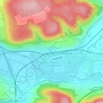
Mapa topográfico Obermaßfeld-Grimmenthal
Mapa interativo
Clique no mapa para exibir a altitude.
Sobre este mapa
Nome: Mapa topográfico Obermaßfeld-Grimmenthal, altitude, relevo.
Altitude média: 361 m
Altitude mínima: 290 m
Altitude máxima: 486 m
Outros mapas topográficos
Clique em um mapa para visualizar sua topografia, sua altitude e seu relevo.
Birx
Duitsland > Thüringen > Landkreis Schmalkalden-Meiningen
Birx, Hohe Rhön, Landkreis Schmalkalden-Meiningen, Thüringen, Duitsland
Altitude média: 725 m
Christes
Duitsland > Thüringen > Landkreis Schmalkalden-Meiningen
Christes, Dolmar-Salzbrücke, Landkreis Schmalkalden-Meiningen, Thüringen, Duitsland
Altitude média: 486 m
Oberhof
Duitsland > Thüringen > Landkreis Schmalkalden-Meiningen
Oberhof, Landkreis Schmalkalden-Meiningen, Thüringen, 98559, Duitsland
Altitude média: 749 m