
Faça uma doação
Mapa topográfico Tuva Republic
Clique no mapa para exibir a altitude.
Faça uma doação
Sobre este mapa
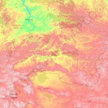
Nome: Mapa topográfico Tuva Republic, altitude, relevo.
Local: Tuva Republic, Siberian Federal District, Russia (49.74293 88.79200 53.72893 99.27370)
Altitude média: 1.411 m
Altitude mínima: 224 m
Altitude máxima: 3.924 m
Faça uma doação
Outros mapas topográficos
Clique em um mapa para visualizar sua topografia, sua altitude e seu relevo.
Faça uma doação
Faça uma doação
Faça uma doação
Faça uma doação
Faça uma doação
Siberia
Russia > Krasnoyarsk Krai > Boguchansky Rayon
Eastern and central Sakha comprises numerous north–south mountain ranges of various ages. These mountains extend up to almost 3,000 metres (9,800 ft), but above a few hundred metres they are almost completely devoid of vegetation. The Verkhoyansk Range was extensively glaciated in the Pleistocene, but the…
Altitude média: 346 m
Faça uma doação
Makhachkala
Russia > Republic of Dagestan > Makhachkala Urban Okrug > Makhachkala
Altitude média: 93 m
Faça uma doação
Yekaterinburg
Russia > Sverdlovsk Oblast > Yekaterinburg Municipality > Yekaterinburg
Altitude média: 274 m
Faça uma doação
Omsk
Russia > Omsk Oblast > Omsk > Omsk
Omsk is situated in the south of the West Siberian Plain along the banks of the north-flowing Irtysh at its confluence with the Om River. The city has an elevation of 87 meters (285 ft) above mean sea level at its highest point.
Altitude média: 105 m
Novy Urengoy
Russia > Yamalo-Nenets Autonomous Okrug > городской округ Новый Уренгой > Novy Urengoy
Altitude média: 60 m
Faça uma doação
Faça uma doação
Moscow
Moscow is situated on the banks of the Moskva River, which flows for just over 500 km (311 mi) through the East European Plain in central Russia, not far from the natural border of the forest and forest-steppe zone. 49 bridges span the river and its canals within the city's limits. The elevation of Moscow at…
Altitude média: 159 m