
Obrigado por apoiar este site ❤️
Faça uma doação
Faça uma doação
Mapa topográfico Sunnyside Playground
Clique no mapa para exibir a altitude.
Obrigado por apoiar este site ❤️
Faça uma doação
Faça uma doação
Sobre este mapa
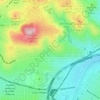
Nome: Mapa topográfico Sunnyside Playground, altitude, relevo.
Altitude média: 117 m
Altitude mínima: 32 m
Altitude máxima: 271 m
Obrigado por apoiar este site ❤️
Faça uma doação
Faça uma doação
Outros mapas topográficos
Clique em um mapa para visualizar sua topografia, sua altitude e seu relevo.
Mount Davidson
United States > California > San Francisco
Mount Davidson is the highest natural point in San Francisco, California, with an elevation of 928 feet (283 m). It is located near the geographical center of the city, south of Twin Peaks and Portola Drive and to the west of Diamond Heights and Glen Park. It dominates the southeastern view from most of…
Altitude média: 138 m
Obrigado por apoiar este site ❤️
Faça uma doação
Faça uma doação