
Obrigado por apoiar este site ❤️
Faça uma doação
Faça uma doação
Mapa topográfico Diktel
Clique no mapa para exibir a altitude.
Obrigado por apoiar este site ❤️
Faça uma doação
Faça uma doação
Diktel
Diktel was renamed to Rupakot Majhuwagadhi on 10 March 2017 after merging some more VDCs. The municipality is divided into 15 wards. It is on 700 m to 2250 m of elevation from sea level. The area of the municipality is 246.51 km2. There are 10,050 households with population of 46,903. By 2020, the name commonly used name Diktel was re-added to the municipality's official name.
Obrigado por apoiar este site ❤️
Faça uma doação
Faça uma doação
Sobre este mapa
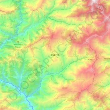
Nome: Mapa topográfico Diktel, altitude, relevo.
Local: Diktel, Rupakot Majhuwagadhi, Khotang, Koshi Province, Nepal (27.19328 86.77318 27.23328 86.81318)
Altitude média: 1.492 m
Altitude mínima: 1.033 m
Altitude máxima: 2.012 m
Obrigado por apoiar este site ❤️
Faça uma doação
Faça uma doação
Outros mapas topográficos
Clique em um mapa para visualizar sua topografia, sua altitude e seu relevo.