
Mapa topográfico Blanca Peak
Mapa interativo
Clique no mapa para exibir a altitude.
Sobre este mapa
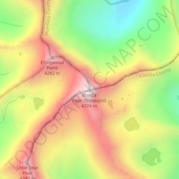
Nome: Mapa topográfico Blanca Peak, altitude, relevo.
Local: Blanca Peak, Alamosa County, Colorado, United States (37.57756 -105.48558 37.57766 -105.48548)
Altitude média: 3.871 m
Altitude mínima: 3.347 m
Altitude máxima: 4.363 m
Blanca Peak is notable not only for its absolute height, but also for its great local relief and dominant position at the end of the range, rising high above the San Luis Valley to the west. For example, it rises nearly 7,000 feet (2,100 m) over the edge of the San Luis Valley in only 6 miles (9.7 km). Blanca is also the third most topographically prominent peak in Colorado; it is separated from the higher peaks in the Sawatch Range by relatively low Poncha Pass at 9,019 feet (2,749 m).
Outros mapas topográficos
Clique em um mapa para visualizar sua topografia, sua altitude e seu relevo.
Lake Como
United States > Colorado > Alamosa County
Lake Como, Alamosa County, Colorado, United States
Altitude média: 3.718 m