
Mapa topográfico Lower Rea
Mapa interativo
Clique no mapa para exibir a altitude.
Sobre este mapa
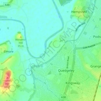
Nome: Mapa topográfico Lower Rea, altitude, relevo.
Altitude média: 17 m
Altitude mínima: 3 m
Altitude máxima: 60 m
Outros mapas topográficos
Clique em um mapa para visualizar sua topografia, sua altitude e seu relevo.
White City
United Kingdom > England > Gloucestershire > Gloucester
White City, Gloucester, Gloucestershire, England, GL4 6UL, United Kingdom
Altitude média: 38 m
Gloucester
United Kingdom > England > Gloucestershire > Gloucester
Gloucester, Gloucestershire, South West England, England, GL1 2AP, United Kingdom
Altitude média: 83 m