
Mapa topográfico Village of Horseheads
Mapa interativo
Clique no mapa para exibir a altitude.
Sobre este mapa
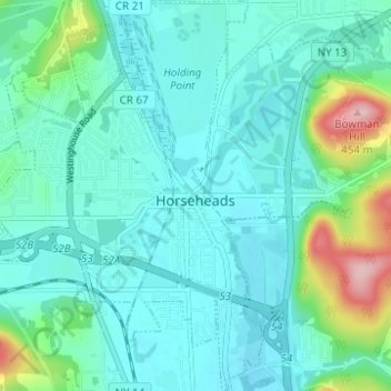
Nome: Mapa topográfico Village of Horseheads, altitude, relevo.
Altitude média: 298 m
Altitude mínima: 263 m
Altitude máxima: 454 m
Outros mapas topográficos
Clique em um mapa para visualizar sua topografia, sua altitude e seu relevo.
West Elmira
United States > New York > Chemung County
West Elmira, Town of Elmira, Chemung County, New York, 14905, United States
Altitude média: 320 m
Brand Park
United States > New York > Chemung County > City of Elmira
Brand Park, City of Elmira, Chemung County, New York, United States
Altitude média: 270 m
City of Elmira
United States > New York > Chemung County > City of Elmira
City of Elmira, Ashland, Chemung County, New York, United States
Altitude média: 296 m
Village of Millport
United States > New York > Chemung County
Village of Millport, Town of Veteran, Chemung County, New York, United States
Altitude média: 296 m
Langdon Hill
United States > New York > Chemung County
Langdon Hill, Chemung County, New York, 14838, United States
Altitude média: 449 m
Lowman
United States > New York > Chemung County
Lowman, Town of Ashland, Chemung County, New York, 14894, United States
Altitude média: 290 m