
Faça uma doação
Mapa topográfico Vilaller
Clique no mapa para exibir a altitude.
Faça uma doação
Sobre este mapa
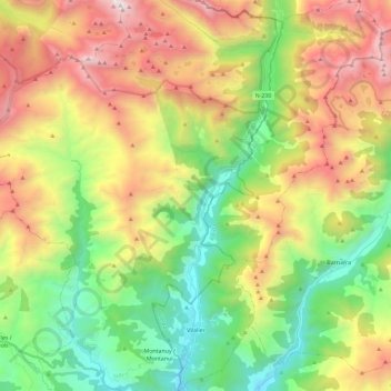
Nome: Mapa topográfico Vilaller, altitude, relevo.
Local: Vilaller, Alta Ribagorça, Lleida, Catalonia, 25552, Spain (42.44928 0.69049 42.61948 0.82632)
Altitude média: 1.845 m
Altitude mínima: 918 m
Altitude máxima: 3.207 m
Faça uma doação
Outros mapas topográficos
Clique em um mapa para visualizar sua topografia, sua altitude e seu relevo.
Taüll
Spain > Catalonia > Alta Ribagorça > la Vall de Boí
Located at an altitude of 1,520 meters in the Sant Martí valley, a small valley in the Valley of Boí. The closest river is the Sant Martí river, Noguera de Tor affluent. A ravine splits the village in two districts: La Guinsa and Lo Barri. La Guinsa goes from the entrance of the village to the ravine, and…
Altitude média: 1.707 m